First flight(LAB1)
1. Location: Connection Point Church
(2541 Cumberland Ave, West Lafayette, IN 47906)
2. Check Out Procedures:
⁃ Mavic 2 Pro AC
⁃ Firmware Update to Mavic 2 V01.00.0790
⁃ Battery MV3/3350/70 Fully Charged
⁃ Controller AC Fully charged
⁃ Propeller Color 2 Gray/2 Black
⁃ Safe Vest:2
3. Preflight:
⁃ FAA Part 107 certificate: 4608538 Valid
⁃ METAR: KLAF 111854Z 20004KT 7SM OVC009 08/06 A2977 RMK AO2 SLP082 T00830061
⁃ NO TFR FOR KLAF/LAF, NO NOTAM HAZARDS FOR DESIGNATED FLIGHT AREA
⁃ Visibility: 7 SM
⁃ Ceiling: 900ft AGL
⁃ Temperature: 8.3C/47F
⁃ Air Pressure: 1007 hPa
⁃ Wind: 160@4kts
⁃ Precipitation: 5% Acc. NOAA, 95% of sky coverage.
⁃ No flight restrictions at designated flight area. (According to DJI Geozone, Authorization has men approved)
4. Potential Flight Hazards

- Potential flight hazards
- the birds
- some obstacles on the parking lot (three lights)
- Emergency landing location
- the whole parking lot that is flat. It is stable to land without a landing pad in an emergency.
5. Contingency plans
- return to home at current altitude
- land on the emergency landing location manually as soon as possible
6. The pictures in flight

(Launch site)
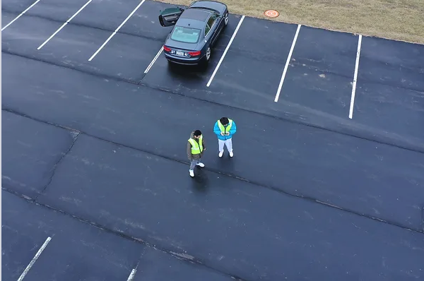
(Pilot and VO)

(Panoramic of the surroundings)

(The aircraft in flight)
7. Any challenges
The birds were rapidly approaching the drone when I flew, I lowered the altitude to get as far away from the birds as possible and landed on the emergency landing location. I’ve never had this kind of experience so far. It was a great chance to learn lessons physically in an emergency.


Comments
Post a Comment